Monday 31 December 2012

Pontville

The area around Pontville was first explored by Europeans in early 1804 and by 1806, with serious food shortages in Hobart Town, expeditions of soldiers were being sent into this area to kill kangaroos and emus. It is claimed that during one of these expeditions Private Hugh Germain, a well educated member of the Royal Marines, started giving various local sites exotic names. Thus, only a few kilometres north of Pontville, lies the incongruously named village of Bagdad and Pontville is actually situated on the banks of the equally incongruously named, Jordan River. It is said that Germain travelled through the area with a copy of The Bible and the Arabian Nights and delighted in giving places names like Jerusalem, Jericho, Jordan, and Lake Tiberius. In fact the headwaters of the Jordan River rise in Lake Tiberius before flowing through Jericho.

A small settlement was established at the site during the 1820s. Pontville was sited by Governor Lachlan Macquarie, in 1821, and was an early garrison town, where convicts built the bridge over the Jordan River.
The Sheiling (Gaelic for 'cottage') was built circa 1819 on land belonging to William Kimberley, who originally owned the land on which Pontville was established. The Sheiling was probably once used by police keeping an eye on travellers along the early road.

'The Row' (1824), consisting of five cottages, was built as military accommodation for soldiers overseeing the construction of early roads. An officers' mess built during the 1820s became the Pontville post office in 1861 and is now an antique and gift store.

During the 1830s and 1840s Pontville developed as a staging post and garrison town along the route between Hobart and Launceston, outgrowing the neighbouring village of Brighton. It was also around this time that the Pontville quarries were established. Sandstone quarried here was used in buildings across Tasmania during the 19th century.
The police station (1839) and courthouse (1842) were built on land purchased from Kimberley in 1838.
During the 1840s the sandstone Pontville Bridge was constructed using convict labour, but has been extensively altered since its original construction. The bridge is part of the Midland Highway.
There were more than 2000 people living in the village by the mid-1840s.

St Marks Church of England (1839-41) was designed by architect James Blackburn, who had been transported to Tasmania in 1833 and was pardoned eight years later. The Romanesque-style church was constructed using locally quarried white ashlar stone. The graveyard contains the graves of some of the district's early settlers.
The Roman Catholic Church of St Matthew was completed in 1866 but was rebuilt in 1927-28 after fire destroyed the original. The Congregational Church was built using local stone in 1876.

Pontville, on the Midlands Highway 27 kilometres north of Hobart, is now a tiny, historic village which retains a number buildings from its early settlement. A railway line connected the town with Hobart from 1891 until 1947. Additional excursion trains operated from Hobart, bringing riflemen to the nearby range. During World Wars I and II the area had a major army camp.

Today, Pontville is a tiny village which belies the thriving settlement that existed there in the mid-1840s.  At that time, Pontville was an important stopping point for travellers on route between Hobart and Launceston (Port Dalrymple), a major supplier of stone for the whole of the southern region and boasted a population of more than 2000 residents.  By the 1860s, there were no fewer than six flour mills operating in the area.
Although it is easy to simply pass through Pontville, its bridge, barracks, churches, gracious homes and workers' cottages offer a fine sample of colonial life.

St. Mark's Church is a special design; a highly unusual example of the Romanesque style.  It is another superb example of the work of noted convict architect, James Blackburn.  The National Estate Register records its importance in considerable detail.
Lythgo's Row, or The Barracks is another local landmark.  The first of the cottages was built in the 1840s and sandstone from the quarry in which the Lythgo's Row is situated was used to construct the unusual pylons supporting the bridge nearby.

Pontville is also home to two of the finest examples of surviving colonial architecture, Epsom House & Shene Homestead.
Shene Homestead: http://shene.com.au/

Jericho Probation Station

The convict system had two main advantages in that it emptied the British prisons of criminals and that it was provided a low cost system of labour for the establishment of the colony of Van Diemans' Land. It was the means by which roads, houses, bridges and all law enforcement buildings such as prisons, courthouses and military barracks were built. It was an authoritarian system where punishments such as flogging, solitary confinement and hard labour were common. For the first ten or so years of settlement there were far more convicts than free settlers so that 'trusties' and convicts holding 'tickets' cleared land and established farms of between four and forty hectares. Many of these people had a good deal of freedom and were criticised by the free settlers for being ' drunk and immoral.' Convict skilled tradesmen and artisans were in great demand as were those with literacy skills who acted as clerks and bookkeepers. Convicts were assigned to settlers who often treated them as virtual slaves. There was no accountability on the part of settlers as the government was relieved of the burden of housing, feeding and general management .

Isolated as Tasmania was, the penal system was the subject of much debate in England with the followers of philosopher Jeremy Bentham urging reform. It was said that ' the condition of the transported convict is a lottery' and was 'slave labour.'

However, it wasn't until the 1830s that the system of Probation established nineteen Stations throughout the state. In the Southern Midlands region, building was commenced on a Probation Station at Jerusalem ( later Colebrook) in 1834. The Jericho Probation Station was established in 1841 and was constructed to house the 200 convicts who were used to construct the road linking Hobart and Launceston.

The Probation system was divided into three stages with
Stage 1) convicts serving 2 -4 years either at Port Arthur, Norfolk Island, Macquarie Harbour etc. The first stage could also be served in England on the 'hulks' or in a prison.
Stage 2) would be served in public works with wages of tea and sugar.
Stage 3) meant that convicts could virtually work like free men at fencing, stock keeping and cultivating land.

Settlers and pastoralists would be required to pay the sixpence- ninepence per day for their labour.
Following the three stages of probation the convict could receive a ticket of leave, a ‘probationary and revocable pardon’ only valid in the colony in which it was granted. Finally, the convict could receive a conditional or absolute pardon. Each convict had to go through each stage and could be reverted back a stage for bad behaviour.But the Probation system did not work. The settlers and pastoralists were reluctant to pay for labour which they had previously obtained freely, many refusing outright to have anything to do with the system. Stations soon became choked with convicts waiting to be employed. Nor could the colony afford wages for public works due to lack of capital and the refusal of the Colonial Office in England to increase money for the colony.. The convicts were soon seen to be 'out of control' with escapes, fights and 'unnatural crimes.' Charles La Trobe said the Probation system . . . (had been ) a fatal experiment . . . and the sooner it is put an end to the better, for the credit of the Nation and of humanity.'

The probation system was implemented in 1839 as an experiment but continued as a major phase of convict management until after transportation to Van Diemen’s Land ceased in 1853. It was a uniquely Australian approach to convict management, intended to provide punishment to ensure that transportation remained a deterrent, but also to provide opportunities for reform and betterment. Probation stations existed only in Van Diemen’s Land, although Norfolk island also participated in the probation system.
These walls are all that remain of the station which was built to house convicts under the probation system in 1841. It was in operation until late in 1845 when the buildings were taken over by the roads department and used to house convicts working on the main road. The buildings were closed in 1848. The superintendent lived in a stone house a 1/4 mile to the north.

Friday 28 December 2012

Royal Tasmanian Botanical Gardens

The Royal Tasmanian Botanical Gardens, which cover an area of approximately 14 hectares (34.6 acres), were established in Hobart in 1818 (making it the 2nd oldest gardens in Australia, behind Sydney) and are located within the Queens Domain. The Gardens hold historic plant collections and a large number of significant trees, many dating back to the nineteenth century. It also has an increasing number of important conservation collections of Tasmanian plants, of which the King's Lomatia is one of the most unusual, and the world's only Subantarctic Plant House. Here, plants from subantarctic islands in high southern latitudes are displayed in a climatically-controlled environment, where chilly fogs and mists mirror the wet, cold conditions of their island homes. The plants of the Subantarctic Plant House have been collected by Gardens staff and associated scientists on field trips to Macquarie Island.

Established in 1818, the RTBG is the second oldest botanical garden in Australia after Sydney. Developed on the site of Hangan’s Farm on the banks of the River Derwent, the number of nearby middens attests to a rich and far longer history of human habitation. At first they functioned as the lieutenant-governor's garden, with limited public visitation during the first superintendent William Davidson's time. Like other colonial era botanical gardens, the RTBG played a vital role in the early establishment of the colony as a central point for the introduction and dissemination of food producing plants for the growing settlement.

The RTBG boasts strong links to Tasmania’s convict past, with convicts providing much of the labour for the early development of the gardens Many of the older structures were also built with convict labour, including the Arthur Wall, one of the few heated walls in the Southern Hemisphere, and the Eardley-Wilmot Wall, which was rumoured to have been built to keep out locusts!

For many years convict labourers and garden superintendents lived side by side at the gardens, but while the history of the garden’s former superintendents and directors is reasonably well documented, very little is known about the convicts who worked on site.

The Gardens contain some of Tasmania's most significant built heritage. These structures form the bare bones around which the Gardens have waxed and waned over the years Important structures include the Superintendent's cottage (now the Administration Office) closely followed by the Arthur Wall which Lt-Governor Arthur had built in 1829. This wall, of a design common in Britain, is hollow and capable of being heated to encourage the growth of fruit trees planted beside it. Nobody had done their homework on Tasmania's climate, so it was soon discovered that fruit trees did very well without any help, and the wall was never used in this way. Arthur requested seeds and plants and in 1829, in response to his initial request, possibly both were sent, primarily 'forest' trees, grasses, grains, and nuts.

At the northern end of this wall stands another cottage, built in 1845 originally for the head gardener, but which has since been a porter's lodge, overseer's residence, tea rooms, board room and administration office. Shortly before that, another brick wall, the longest convict built structure in Australia, transected the landscape from north to south. This is the Eardley-Wilmot wall, which legend states was built to keep out a plague of grasshoppers. Another early structure was the Lily Pond, formed by damming a stream from the Domain, and initially used for irrigation. It was not until 1878 that the spectacular set of wrought iron gates made in the north of England were installed. The Conservatory was constructed in 1939.

By 1844, responsibility for the Gardens had been transferred to the new Royal Society of Van Diemen's Land. FW Newman was appointed Superintendent in 1845, and probably commenced the pinetum and the collection of conifers for which the garden is widely known. This pinetum was expanded under Francis Abbott (1859–1903), with certain conifers arriving almost at the same time as they were introduced into England, Norfolk Island pines and tree fern plants were exported overseas as exchange plants while exotic trees and shrubs were sent back, and rose varieties and orchard trees were consistently added to.
Plant distribution by the Royal Society to public places and private gardens within Tasmania also occurred, its legacy immense. Franklin Square, Low Head Pilot Station and the Salmon Ponds are examples of this distribution. In 1856, a plan attributed to William Porden Kay appeared for the Gardens, probably allowing for a parterre garden section, promenade walks and orchard, and the major part was implemented.

In 1939 the Conservatory was built and during the 1970s, more land was acquired and a Japanese Garden and French Memorial Fountain were created. The Royal Tasmanian Botanical Gardens are intimate gardens which reflect the botanical scientific input of managers across time, coupled with the flavour of a nineteenth-century Victorian park space. The Gardens have an annual tulip festival and other colourful displays; those in the Conservatory are unique. Recent construction in the Gardens reflects the changing focus of botanic gardens worldwide, providing facilities for the delivery of education, interpretation, conservation and research programs.
Highlights to visit include: The Japanese Garden, The Rainforest & Lily Pond.


And especially for the kids and young at heart, you cant go past having a ride on the Steam Carousel. This 1882 Steam Carousel was lovingly restored for the Tasmanian children and families over 5 years in Kingston, just out of Hobart. After touring tasmania's best and biggest shows and events it has entertained hundreds of thousands of tourists and local tasmanians alike. From the Taste of Tasmania, to the Sydney to Hobart Yacht race, and every year on Constitution Dock for 10 years over christmas/new years the ride is a shining beacon of history that Tasmania has loved and appreciated since its rebirth. Now settled in the Tasmanian Royal Botanical Gardens where it continues to provide enjoyment and exhiliration for kids, adults and grandma and grandpa.


Website; Royal Tasmanian Botanical Gardens

Update 18/11/14 - Thank you to Bruce Lewis for notifying me that the Steam Carousel is no longer operating in the Botanical gardens. A real shame!

Monday 24 December 2012

Mt Nelson Signal Station

The signal station at Mt Nelson was the first to be constructed in Tasmania. Built on the order of Governor Macquarie in 1811 as a station to report shipping in and out of the Port of Hobart, it replaced the use of smoke signals at Betsey Island. The station was to play an important role in maritime communications for the next 158 years.
Signalling was initially done using flags, however by 1831, a three-armed semaphore (an upright post with arms) was operating which was capable of dealing with 666 code signals.
This was replaced in 1838 by a six-armed semaphore over 24 metres high which could handle over 900 000 separate signals.


In 1836 the station was linked into the Tasman Peninsula system. Through this network of of semaphore stations, messages could be rapidly relayed from the penal settlement at Port Arthur to Hobart. The Hobart semaphore is located at the Mulgrave Battery in Castray Esplanade in Battery Point.
Semaphore messages were sent by raising and lowering the arms to set positions. A 20 word message could be sent from Hobart and received at Port Arthur in 15 minutes. Three signal men usually worked and lived on site, often accompanied by their families. Work was carried out in all weather conditions on watches of three hours from 6am to 9pm. The current cafe and restaurant is in a building built for the head signalman in 1897.

The signal station was operated by the military from its inception until 1858, when the newly established Marine Board of Hobart took over control. By 1860, the station had developed into a two-tiered system, with the top six arm semaphore dealing with Port Arthur maritime traffic, while the lower arm dealt with Hobart traffic.

In 1880, a mere four years after the invention of the telephone by Alexander Graham Bell, a telephone line - Tasmania's first - was established between Hobart and Mt Nelson. The arrival of this new technology resulted in the the removal of the semaphore and its replacement with a flagstaff - but not before the semaphore sent one last message (no. 343  which means "forgotten").  

In 1958 a base station for ship-to-shore radio-telephone, the second of its kind in Australia, was installed at Mt Nelson. The Mt Nelson Signal Station ceased operations in 1969, ending 158 years of Tasmanian communications history.
Management of the Mt Nelson site was transferred from the Marine Board to the Parks and Wildlife Service in 1979.
Today, the station retains a strong link with the past. Every day, the Tasmanian State flag is flown, and International Marine Signal Flags are used to welcome visiting ships and for other special occasions. Fantastic photo opportunities of the beautiful views back across Hobart and down towards the entrance to the Derwent. The cafe and restaurant offer nice, reasonably priced meals whilst sitting on the balcony of the old Head Signalmans cottage taking in the views. A great way to pass away a quiet afternoon. There is a picnic area nearby with unsheltered picnic tables and BBQs and for those feeling a bit more energetic, the adjoining Bicentennial Park and Truganini Conservation Area both have extensive walking tracks.

Information sourced from Parks Tas website:

Cafe website:  www.thestationcafe.com.au

Friday 21 December 2012

Battery Point

Battery Point is a suburb of of Hobart. Battery Point is named after the battery of guns which were established on the point in 1818 as part of the Hobart coastal defences. The battery no longer exists.
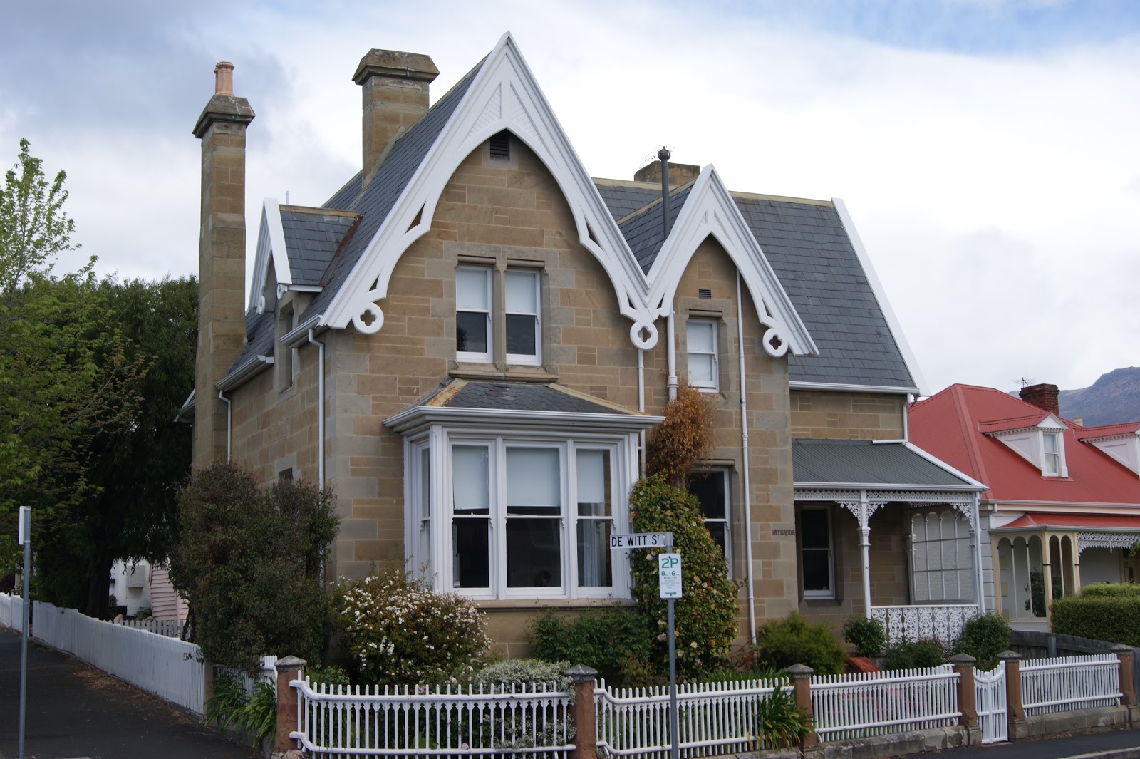
The area is generally known as one of the city's more prestigious suburbs, with many large and extravagant homes and apartment blocks. It adjoins the waterfront Salamanca area as well as the nearby prestigious suburb of Sandy Bay.

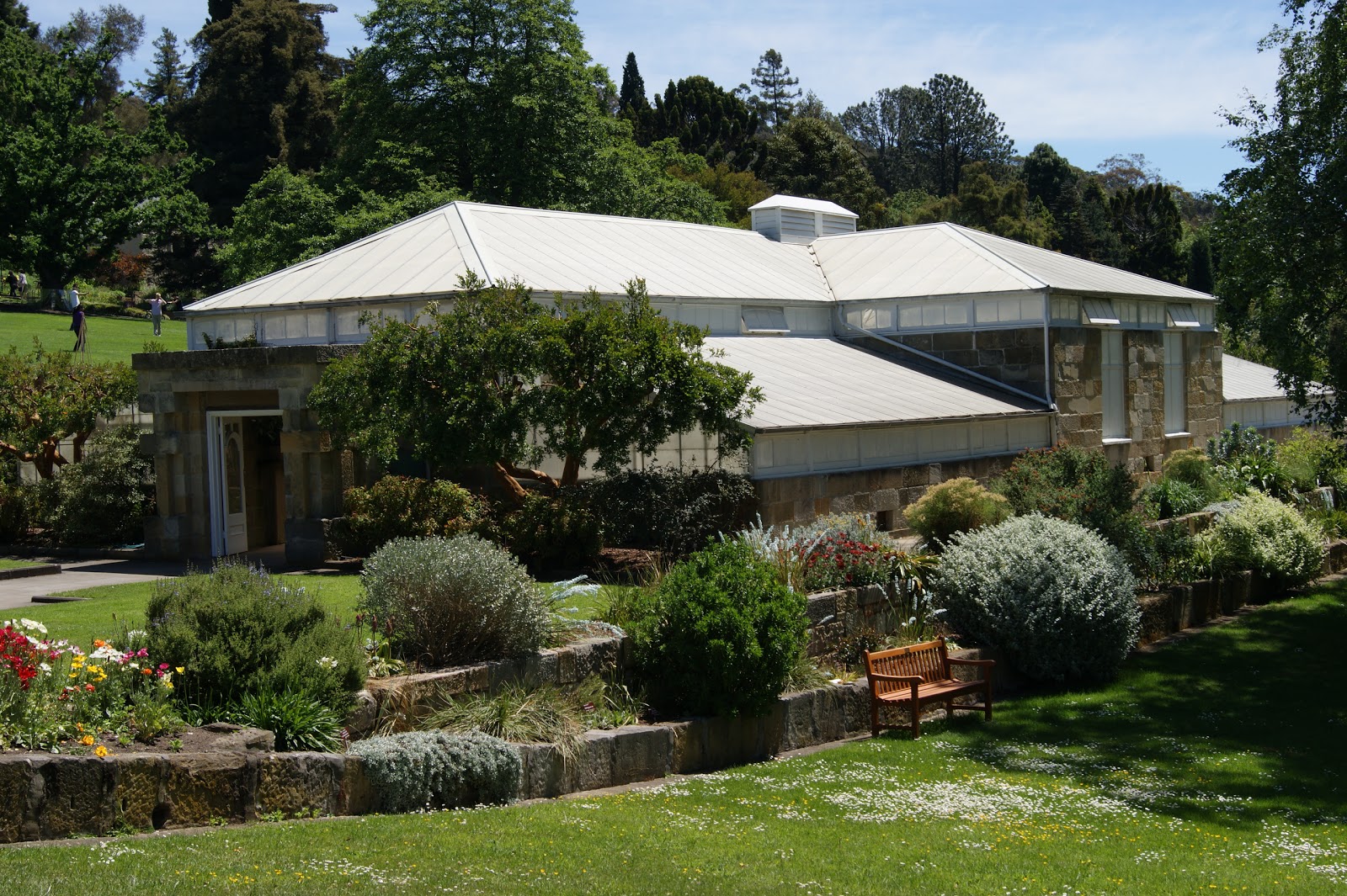
Battery Point has a large number of historic houses dating from the first European settlement of 'Hobart Town'. Probably the most significant is Arthur Circus with its cottages, mostly originally constructed for the officers of the garrison. Arthur Circus is the only circus in Australia.
Rev. Robert Knopwood, the colony's first Chaplain, settled in the area in 1804 after Lieutenant-Governor Collins granted Knopwood 30 acres of land on the northern slope of Battery Point. He built a small house on his land and began to farm. In 1818 the new Lieutenant-Governor, Sorell, had Mulgrave Battery built on 8 acres of land which had been reserved on the point.
In the same year Governor Macquarie of NSW granted Sorell 90 acres, which comprised the southern half of Battery Point. Sorell did nothing to improve his land.

The land granted to Knopwood had been previously occupied by the Mouheneene Band of the South East tribe, and known to them as Nibberloone or Linghe. The Mouheneene were the most maritime of the indigenous people, and made frequent trips to Bruny Island. The band consisted of 70-80 people. Aboriginal women dived for crayfish at nearby Crayfish Point, Sandy Bay. Wooreddy, one of the band's number, has described the reaction of his people on seeing European boats for the first time. The colony's burial ground was immediately to the north of Knopwood's block, which was some distance from the new town of Hobart. Knopwood began to build his house, Cottage Green, on 2 January 1805. He pitched his marquee near the cottage on 22 February 1805, and moved in on 14 March. The grant to him was recorded on 1 January 1806.

Groups of Aborigines continued to visit the land and have friendly meetings with Knopwood and other members of his household. On one occasion Knopwood accompanied a group of Aboriginal women on a crayfish diving expedition to nearby Crayfish Point, Sandy Bay.
The battery built on the point was named Mulgrave Battery after the first Earl of Mulgrave, Master General of the King's Ordnance. Earth ramparts were built, and cannons from a ship installed. The battery was permanently manned by soldiers. It fired a salute on the Prince of Wales' birthday in 1818. In March 1819, the ship Young Lachlan, stolen by 13 convicts, sailed past the battery unobserved.
In 1824 Knopwood subdivided much of his block, and ten merchants and entrepreneurs bought parallel blocks stretching south from the waterline. In the same year Sorell's block passed to Robert Kermode. New Wharf was built along Salamanca Place and officially opened in 1830. It became the centre of Van Diemen's Land whaling and of overseas trade.

Knopwood continued as owner, in absentia, of the part of his estate on which Cottage Green was built. It was sold in 1829. In 1831 it was acquired by Lieutenant-Governor Arthur, and occupied by Roderic O'Connor, Land Commissioner. It was demolished in 1836, shortly after another house named Cottage Green had been built nearby. A semaphore was set up behind Mulgrave Battery in 1829.
The merchants who bought Knopwood's subdivision were aware that plans were afoot to build a new wharf there, the old Wharf along Hunter Street being exposed and inconvenient. The merchants built large mansions, such as Narryna, on their Battery Point blocks. Later they were forced to give up their water frontages. The merchants began to build warehouses on their properties. The first to be completed was Captain Haig's in 1834. New Wharf was built by convicts who were housed in two hulks moored in the Derwent. They quarried stone from Battery Point (behind Salamanca Place), reclaimed land, laid down a road, and built infrastructure which included two wings of an Ordnance Store erected in Castray Esplanade in 1834 and 1836 to the design of John Lee Archer.

Bay whaling was an important industry conducted from New Wharf. 'The Derwent Whaling Club' was founded by James Kelly, whaler and adventurer and others in 1826. The value of the whale fishery peaked in 1837 with whale oil being Hobart's second most valuable export.
In 1824 Lieutenant-Governor Sorell's 90 acre block passed to Robert Kermode. He sold 8 acres of it to the Surveyor-General, George Frankland, who built Secheron there in 1831. John Montague, the Colonial Secretary, built Stowell and lived in it from 1832 to 1839. Other central features of Battery Point were built at this time: the first pub the 'Whaler's Return' in 1834, the windmill in 1836, Kelly's Steps in 1839, and St George's Church (designed by Archer), begun in 1837.
With the development of New Wharf, Battery Point becomes the centre for ship building and maritime industries in Van Diemen's Land.

Battery Point's maritime industry grew as more land on Knopwood's old block was subdivided. 1849-1853 saw the height of shipbuilding activity. Small cottages belonging to seamen and shipwrights began to appear close to the large mansions of the merchants and ship owners. In 1854, Robert Kermode subdivided his estate, opening up the southern half of Battery Point for residential development. A larger portion of this estate was subdivided in 1874. Hampden Road became the shopping centre of the village.
Ship building in Battery Point slips had begun in a small way in the 1830's, J Williamson's yard having been set up in 1830. This tradition was built upon after 1840.

There was considerable development in the Battery Point/Salamanca area over the 44 years during which it was the maritime centre of Tasmania. The remaining stone warehouses along Salamanca Place were completed in the 1840's. In 1840 the stone Customs House was completed, and in 1853 it was converted to Tasmania's new Parliament House. Ex-Lieutenant-Governor Arthur subdivided his property (now known as Arthur's Circus) and it was sold in 1843. In 1845 the large Prince of Wales battery was added above the Mulgrave Battery as part of the new defence of Hobart. Mulgrave Battery was then dismantled. The Prince of Wales battery was used by the Hobart Town Volunteer Artillery to fire salutes and for shot and shell practice from 1858 to 1871. Those who did not heed the warnings to open their windows often had them broken by blasts. 'The Prince of Wales' and 'Shipwright Arms' were both licensed in 1843. The convict architect, James Blackburn, added a spire to St George's Church in 1847. In 1858 eleven pubs operated in Battery Point, many of which had gained a reputation for boisterousness. At the height of the Crimean War in 1854, an additional battery, the Albert Battery, was constructed behind the Prince of Wales Battery.

The St George's Parochial School was founded in 1849, and became Battery Point School in 1853. In 1869 there were 350 children enrolled in the school, which was the second largest in Hobart. 181 of the children were on the 'free list', and conditions in the school were said to be appalling.
The first Battery Point Regatta was held in 1853 but it was spoiled by the politics of Anti-Transportation. Many Tasmanians were protesting against the ongoing transportation of convicts to the island.
Princess Wharf shed is built in the 1880's. This frees up the old warehouses for other uses, and new industry moves in. Steamship companies, many of them overseas owned, forced the local companies out of business. The larger ships also tended to use the new central wharf rather than New Wharf. Wooden ships were also replaced more and more by steel vessels, and ship building went into a slow decline. New industry moved into the area, employing a different type of workforce. An example is W.D. Peacock's jam factory, which operated in 71 Salamanca Place after 1885.

Only one whaling business remained after 1890, that of Alexander Macgregor. Maritime industries continued as major employers, despite the decline in the level of activity compared with the previous period.
Further subdivisions of Battery Point, with corresponding increases in population, occurred until 1930.
Industries which were established in Battery Point included an iron smelter which operated in Castray Esplanade in the 1870's and a number of metal foundries in Salamanca Parade, the Derwent Ironworks and Engineering Company (established by R. Kennedy in 1883) being the largest. The Anglo-American Guano Company produced fertiliser from 1861; skin and hide companies, and possibly a glue factory, were other noxious trades. In the 1880's, a steam laundry, bark mill and fruit and vegetable preserving works - all set up near the waterfront - provided work for locals.
A new Battery Point School (an 'architectural masterpiece of the day') was opened in 1885; it was replaced in 1913 by the Albeura Street School and Battery Point children had to leave the suburb for their education.
The Queen Alexandra Maternity Hospital opened in 1908, and served the whole of Hobart. Stowell was converted to a private hospital in 1918.

Leisure, too, was catered for. St David's Burial Ground, which had been closed for some years, was transformed in 1921 to St Davids Park, one of Hobart's most beautiful reserves. And in 1895 Mary Roberts, an early conservationist and lover of native birds, opened her collection to the public as Beaumaris Zoo. One of the exhibits was a thylacine. In 1923, two years after Roberts died, the collection was moved to its final site on the Domain.
During the first decades of the twentieth century, with the disappearance of intercolonial tariffs and the passing of the Commonwealth Navigation Act 1912, some local industries went into decline.
Battery Point industries, already struggling, are further hit by the Depression.

A number of local companies closed in the first decades of the twentieth century. Much of the population of Battery Point rented its accommodation, and during the 1930s the suburb was regarded as rather run down. During the 1940s and 50s many young families left for new housing areas. The population of Battery Point reached its lowest level for many years in 1954.
In 1930 there were still 100 people employed in the maritime related industries, and apples were now a major export from the wharf. The jam factory continued, although it had been taken over by Henry Jones in the early 1920s.
In 1940 Battery Point was selected as a suitable target for a social experiment. Welfare programs and one of the Federal Government's Lady Gowrie Child Centres were set up there. About 70 children attended daily. The Queen Alexandra Hospital was also considerably enlarged during the 1930s and 1950s.

The maritime tradition of Battery Point lived on in the 1950s, with the Blue House (now Irish Murphy's) gaining an international reputation among seamen as a rough house and brothel.
The Cook Plan, a radical scheme of urban renewal for Hobart which was presented in 1948, involved tearing down all the old buildings of Battery Point, and replacing them with 'modern' blocks; Hobart City Council did not put the scheme into effect primarily because of the cost that would be involved. The plan was also opposed by a group of Battery Point residents who formed the Battery Point Progress Association. In spite of the suburb's seedy reputation, it's 'charm' was beginning to be recognised.

Cheap rental housing becomes available in Battery Point at the same time as the University campus at Sandy Bay extends. As working class families moved out of their rented properties, student tenants began to move in, and the suburb began to acquire a Bohemian reputation. It was also threatened with massive redevelopment, some of which was successfully prevented, some of which took place. After, redevelopment battles were both won and lost by the residents and property values increased. Wealthy tenants moved in and many buildings were renovated.
The developers and residents, who had battled each other over the past decade, came into open conflict.
Battery Point's proximity to the city and prime waterfront views, as well as low property prices, made it an attractive target for developers. As they moved in, consciousness of Battery Point's history raised a desire by many locals to retain the traditional nature of the suburb and despite protests from the Battery Point Progress Association, environmentally insensitive changes occurred, with wheat silos being erected in Salamanca Place in 1962. The suburb was transforming from industrial to residential - as indeed it had been zoned.

The impetus for resident action in opposition to change came in 1966, spurred by the release of the Hobart City Council's Area Transportation Study, which, if implemented, would have radically changed Battery Point. To fight it a group of newer residents formed the Battery Point Society, more radical than the BPPA. To solve the impasse, the Hobart City Council appointed Clarke Gazzard & Co to prepare a planning scheme for Battery Point. This was adopted by the Hobart City Council in 1967, and (with revisions) put into place in 1972. This period saw many conservation battles fought, as well as continued demolitions, such as that of the Prince of Wales Hotel, which was replaced in 1967 by a modern brick building. The BLF placed 'Green Bans' on some of the proposed developments. A new Battery Point planning scheme was put into operation in 1979, Australia's second such scheme. Meanwhile the gentrification and recycling of old buildings continued apace. Several warehouses in Salamanca Place were converted in to the Salamanca Arts Centre in the mid-1970s, and many other buildings have since been converted into galleries, restaurants, cafes and tourist attractions. Salamanca Market has flourished since 1976 and is now one of Hobart's most visited tourist attractions, renowned worldwide.