Sunday 29 May 2016

Old Police Office Site, Pontville

Around 1837, a stone cottage referred to as the “Police Office” on the 1838 subdivisional plan of Pontville was erected on a site overlooking the Jordan River and the old Hobart To Launceston road.  It faced Glebe Street and stood within an acre area set aside for a convict road station. Some of its original sandstone footings remain in place as does an arc of stones bordering the back yard.

A pound in which to detain stray animals was established in the north west corner of the block in 1839. That same year a watch house was constructed in Pontville and a new police residence was erected adjacent to it around 1842. The Police Office cottage remained occupied until it was demolished in approximately 1900. The block remains a vacant block to this day.

Main Text, Information Source & Historic Photos –
Interpretive Sign at the Site

Wednesday 25 May 2016

Paterson's 1804 Landing Site, George Town

November 4th 1804, Lieutenant Colonel William Paterson, and a fleet of ships HMS Buffalo, HMS Lady Nelson, the Francis & the Integrity, entered the mouth of the Tamar on the north coast of Van Diemen’s Land, with a party of 181 including troops, 74 convicts and one free settler. On navigating the Tamar River, Paterson’s ship, the HMS Buffalo, was blown ashore in a gale at Low Head, onto Lagoon Beach.

An outer cove on the eastern side of the Tamar, the site of today’s George Town and originally named ‘Outer Cove’, was chosen temporarily and the settlers made camp there. Paterson even had erected a prefabricated house he had brought with him from Sydney. The house was located at the southern end of what is now Sorell Street. It was still there when Governor Macquarie arrived in December 1811.

Paterson continued to explore the Tamar for a better area, on finding two good streams of fresh water he named the area York Town and would transfer all the settlers here before Christmas although Outer Cove was still used to graze cattle at least until 1806. On November 12th 1804, a large group of Aboriginals approached Paterson's camp, appearing to be quite friendly. They attacked a Marine guard and were fired on with muskets by the Marines. One native was killed and another was wounded.

Despite the hostility of the natives, Paterson continued to explore the area without further incident. Good pasture land and thick forests were found at the head of the Tamar (Launceston). Paterson also discovered and named the North Esk and the South Esk Rivers he was most impressed with the Cataract he discovered in a gorge of the South Esk River. Choosing to stay at the York Town settlement, Lieutenant Paterson moved the small settlement to a more fertile area he named Patersonia, (Launceston) in March 1806.

William Paterson became Lieutenant Governor of Northern Van Diemens Land and later was also Lieutenant Governor of New South Wales giving him authority over David Collins in the south. Van Diemen's Land was combined under one government in 1812 and was governed from Hobart.

Lieutenant Colonel William Paterson, left Port Dalrymple on January 1st 1809. Paterson was in ill heath and was returning to Sydney Town to take over command of the colony from Lieutenant Colonel Joseph Foveaux. Paterson was in control of the colony until Governor Lachlan Macquarie arrived in January 1810.
William Paterson then began his return journey to England aboard the "Dromedary" but he died at sea on June 21st 1810, aged 54.

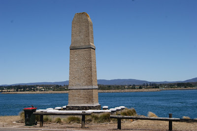
In 1935, a monument commemorating Paterson and the first settlement was erected at Windmill Point near the spot where Paterson originally came ashore and commenced the English settlement of Northern Van Diemen’s Land.

Main Text & Information Source –

Historic Photos – 
Painting of Paterson’s Landing – Print source at George Town Watch House

Sunday 22 May 2016

McKay's Shop & Murphy's Lodge, Kempton

The orginal stone dwelling at the rear of this property was built by Edward Randall and Thomas Croxton (Stonemason) in 1842. In 1852, ownership transferred to John Ashton who then let the premises, including blacksmith, stables and outbuildings. It came to be known as Murphy’s Lodge when run by the Murphy’s as a lodging house. Tenants in the 1850’s included an unscrupulous bootmaker and his wife whose “other business” included an illegal brothel.

The present shop & dwelling was built in 1910 when the property was purchased by the nearby McKay’s Bakery. The sisters Dorcas & Florence Mckay sold the produce of the bakery and later general lines, lollies and reputedly the most wonderful home made ice blocks.

The current businesses utilizing the shop areas were established in 2007 and the stone house is now a private residence.

Main Text & Information Source – 
Interpretive Sign at the Site

Wednesday 18 May 2016

Old Evandale State School & Headmasters Residence

Designed by W.W. Eldridge and built at the Evandale State School in 1889. The building is a fine single storey brick Gothic Revival schoolhouse built in 1889. It was designed for 120 children and was the first state school in the district. The school was extensively renovated in 1929. An infant classroom was added at the time and another large room was divided in two. It served as the State School until 1952 when the current primary school was constructed.

The building was remodeled again in 1986 when the Evandale Municipal Council moved from its original building in Russell St. The building was used as the Municipal Council Chambers until council was amalgamated into the Northern Midlands Council in 1993.

In 1994, the building was reopened as the Tourism, History and community centre where it continues to provide tourist information and house Evandale’s archival records, a collection of historical photographs, local artifacts and a subscription library.

Next door is the former State School Headmaster’s residence. It is a fine two storey Victorian Gothic house built in 1889 by J.H. Batten for the Education Department. Headmasters of the Evandale State School lived in this house for the next eighty years. The first headmaster was Alban Roper. This property is now a private residence.

Main Text & Information Source –
Australian Heritage Database
“Evandale Heritage Walk” brochure – Evandale Community Centre 1992

Historic Photo – 

Sunday 15 May 2016

St Paul's Church, Oatlands

Virtually, every settlement in Australian had a church, the overwhelming majority of which were in the Gothic style. This neo-Gothic style church was commissioned by the first Roman Catholic Bishop of Hobart, Robert William Willson.

This church is one of only two of Augustus Welby Northmore Pugin's buildings constructed from highly detailed accurate scale models made in London by George Myers, his favoured builder. The design dates from 1843 and the models were brought to Tasmania in 1844 by Pugin's very close friend Robert William Willson.

These church designs are only to be found in England, Ireland and Australia. In Tasmania the group of his churches, St Patrick's, Colebrook, St Paul's Oatlands, and additions to St John's, Richmond formed a close unspoiled group of Pugin small village churches that can be found nowhere else, including England and Ireland.

Construction was started on a crown land grant in the village of Oatlands in 1850 with the laying of the foundation stone on 9th April 1850. The construction of St Paul’s church was supervised by Hobart architect Frederick Thomas and it was opened on 26 February 1851 just prior to Pugin’s death. St Paul's Church is a two-compartment church with nave and is constructed from coursed sandstone and has corrugated iron roofs and a scraped interior, originally plastered.

Essentially, the building is intact and presents as when it was first completed. St Paul’s is a perfect example of Pugin’s ideal for the revival of a small medieval village church.

Main Text & Information Sources –
Interpretive Sign at the Site
Australian Heritage Database
“Oatlands…A Colonial Treasure” – Walter.B.Pridmore

Historic Photos – 

Wednesday 11 May 2016

Kings Bridge, Launceston

William Doyne was trained in civil engineering in England on the London South Western Railway and later worked on the construction of a railway near Hamburg in Germany. He continued his railway career as Manager and Engineer for the Rugby and Leamington spa Railway in England. For this railway he designed and built a wrought iron lattice bridge about which he presented two prizewinning papers to the Institution of Civil Engineers.

In about 1861, Doyne was engaged by the West Tamar Road Trust to design a bridge across Cataract Gorge, Launceston. His wrought iron arch design was accepted and the bridge parts were fabricated in England and shipped from London in 1863. The parts were transported to Launceston, assembled on a pontoon, floated into position and then lowered on to its abutments on the receding tide. It was officially opened on 4 February 1864 and cost 12,000 pounds

Kings Bridge was originally a single lane metal arch that connected Launceston with the West Tamar region.
Forty years later, in 1904, a duplicate adjacent span, fabricated by Salisbury's foundry in Launceston, was similarly erected and floated into position. This structure was conjoined to the original to provide two lanes, one in each direction. While the dual-carriageway West Tamar Highway now bypasses Kings Bridge on a modern concrete structure, Kings Bridge remains in service providing direct access to the suburb of Trevallyn

Beneath the arches, there are other signs of the spans being separately constructed, differences in the style and materials in the footings, and old brick retaining walls.

A very elegant and gracefully arched open girder steel bridge that forms a fine terminating element to the renowned Launceston Gorge.


Main Text & Information Source –
Australian Heritage Database

Historic Photos –